Cold front vs warm front: weather fronts explained for flight simmers
What a cold front and a warm front are, where their cloud and rain come from, and how to read occlusions and troughs on a real satellite image.
By Joeri Smits, founder of SkyNexus
You load the weather map for your next flight and there they are: blue lines with triangles, red lines with half circles, and a purple line curling into a low. Your route crosses two of them. Nobody ever told you what they mean, so you look at them for a moment, shrug and move on to the METARs.
Those lines say more than most of what is on that screen. Each one tells you what kind of cloud is waiting for you, where the rain falls and what the wind does when you cross it.
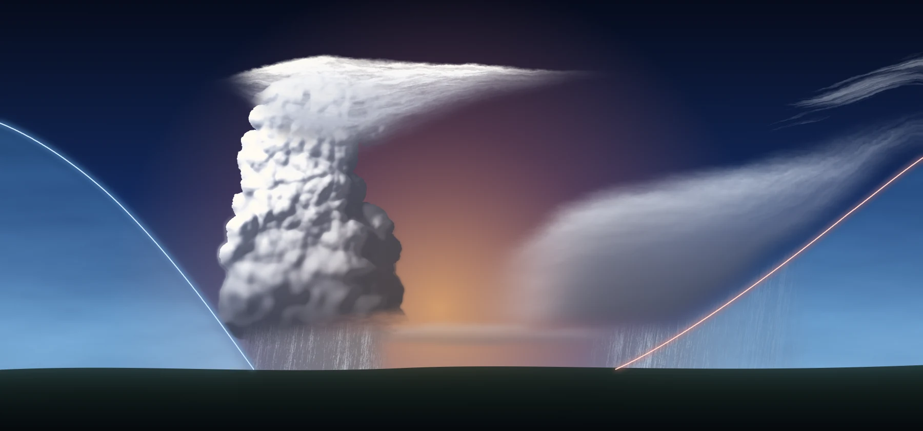
Two kinds of air
Air picks up the character of wherever it has been sitting. A week over the Arctic makes it cold and dry. A week over the subtropical Atlantic makes it warm and moist. Meteorologists call a big body of air like that an air mass, and a single one can cover a large part of a continent.
Cold air is denser than warm air, so when two air masses meet they do not mix easily. The cold air stays low and the warm air ends up above it. The narrow zone between them is a front. A map draws it as a line, but in the sky it is a sloping surface that leans back over the cold air. The name tells you which side is winning: at a cold front the cold air is advancing, at a warm front the warm air is.
Where cloud and rain come from
One piece of physics first, because the rest of this post hangs on it. All air carries some water as invisible vapour, and warm air can carry more of it than cold air. When air rises, the pressure around it falls and it expands. Expanding air cools, by about 3 °C per 1,000 ft. At some height it has cooled so far that the vapour condenses onto tiny specks of dust and salt. That height is the cloud base. All the air in the area reaches it at about the same level, which is why a sky full of cumulus has flat bottoms.
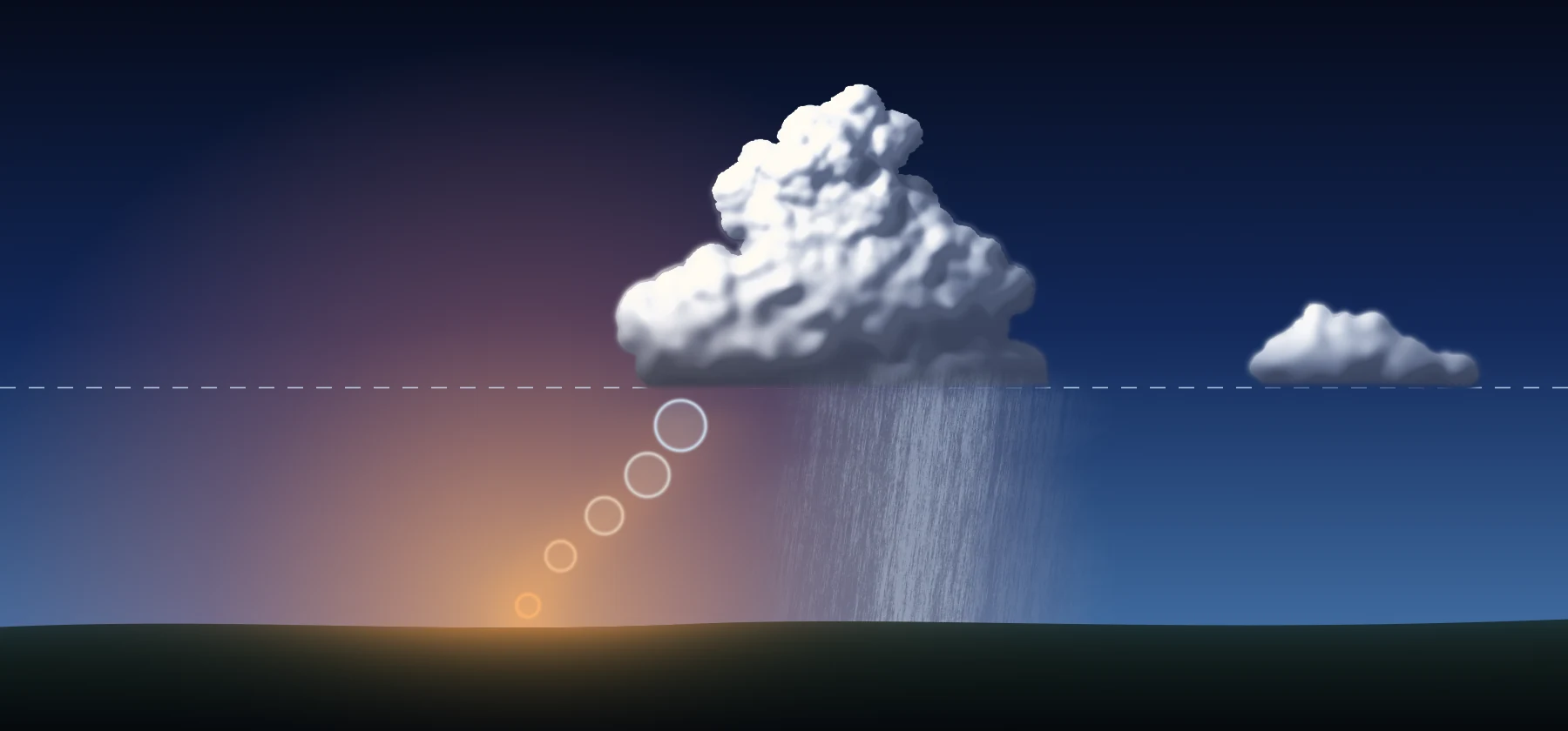
- Warm ground
- Air rises and cools
- Condensation level, cloud starts here
- Growing cumulus
- Same flat base
- Rain
The droplets are so small at first that they float. They get bigger by colliding and merging, and where it is below freezing, ice crystals grow at their expense. Once they are heavy enough they fall as rain or snow. Cloud keeps forming for as long as the air keeps rising.
So keep one idea in your head for the rest of this post: anything that lifts moist air makes cloud. The sun heating the ground does it. A mountain range does it. Air squeezed together near the ground, with nowhere to go but up, does it. And a front does it across hundreds of miles, because a front is a ramp.
The warm front: a long, gentle ramp
At a warm front the warm air is moving in and the cold air ahead of it is giving way. Warm air cannot push the denser cold air aside, so it slides up over it. That ramp is very shallow, typically somewhere around 1:150 to 1:300. At 1:200 the front is still only 5,000 ft up about 165 NM ahead of where the front meets the ground, the place forecasters call the surface front. The pictures in this post stretch the height enormously, because drawn to scale that ramp would be almost a flat line.
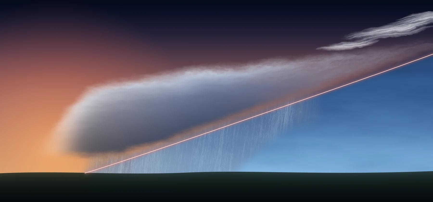
- WARM AIR
- COLD AIR
- Cirrus
- Cirrostratus
- Altostratus
- Nimbostratus
- Rain ahead of the front
- Warm front, on the ground
All along that ramp the rising air cools and makes cloud, and because the ramp is so long, the cloud reaches far ahead of the front on the ground. The first sign comes high and early, often several hundred NM ahead: thin streaks of cirrus, made of ice, typically somewhere between FL200 and FL400. That cirrus does not sit neatly on the ramp, because high cloud drifts with the fast winds up there, but it is the classic first warning. Then the sky fills in with cirrostratus, a milky sheet that can put a halo around the sun or moon. Next comes altostratus in the middle levels, roughly 7,000 to 20,000 ft, thick enough to turn the sun into a pale disc. Last comes nimbostratus, the flat grey layer with a base that can sink to a few hundred feet, and the steady rain or snow that falls out of it.
Fly towards a warm front and that sequence goes past your windscreen in order. The rain band is wide, often more than 100 NM, and it falls ahead of the surface front, through the cold air. It moistens that air on the way down, so low stratus and poor visibility can build under the layer. On the ground it can rain for hours. When the surface front finally passes, the rain eases, it gets milder, and in the northern hemisphere the wind veers, which means it turns clockwise.
The cold front: a steep wall
At a cold front the cold air is the one moving. It hugs the ground and pushes under the warm air like a wedge. Friction holds back the air right at the surface, so the front of the wedge piles up into a blunt nose. The slope is typically around 1:50 to 1:100, several times steeper than a warm front.
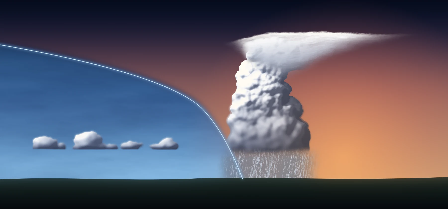
- COLD AIR
- WARM AIR
- Clearer air behind
- Cumulonimbus
- Anvil
- Heavy shower
- Cold front, steep nose, cold air pushing under
A steep ramp lifts the warm air fast, over a short distance. So instead of a long sheet you get tall cloud along a narrow line. The heavy weather is usually only tens of NM wide, even though the band of cloud around it can be far wider. If the warm air is moist and unstable, meaning that once nudged it keeps rising on its own, you get cumulonimbus, or CB for short, with tops that can reach the tropopause, the top of the weather layer. That brings heavy showers, hail and thunder. At 450 kt you cross 30 NM of it in four minutes, so the time to decide on a way around is before you get there.
Not every cold front is a wall of storms. How violent it gets depends on the warm air it lifts, and plenty of cold fronts are no more than a narrow band of rain and a wind shift. When one passes you do feel it, though: a burst of rain, gusts, the wind veering sharply, the temperature dropping and the pressure starting to rise. Behind it the sky opens up and the visibility is usually very good, with cumulus building in the cold air.
The warm sector and the whole system
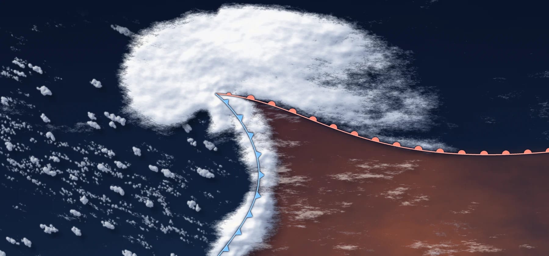
Fronts rarely come alone. Usually they are the two arms of one low. Here is the picture from the start of this post again, now with the labels on, and this time the names should mean something.
- COLD AIR
- WARM AIR
- COLD AIR
- Cumulonimbus
- Anvil at the tropopause
- Cirrus
- Cirrostratus
- Altostratus
- Nimbostratus
- Cold front, narrow band, heavy showers
- Warm front, wide band, steady rain
Stand on the right of that picture and let the system roll over you. First the warm front, with its high cloud and hours of rain. Then the warm sector, the wedge of mild, humid air between the two fronts. The rain stops or turns to drizzle, and over the sea especially the sector is often full of low stratus. Then the cold front, with showers, gusts and a wind shift. Then the clearing cold air behind it.
From above, the same low looks like this. In the northern hemisphere air turns anticlockwise around a low, and that rotation swings the fronts around it: warm air is carried north on the east side, cold air south on the west side. The symbols point the way each front is going. The cloud forms a comma, with a head around the low and a tail along the cold front. Remember that comma, because you will see it again on a real satellite image. In the southern hemisphere it is all mirrored and lows turn clockwise.
- Low
- Head of the comma
- Cloud shield
- Warm front
- Cold front
- WARM SECTOR
- COLD AIR
The occlusion: a low that has wound up
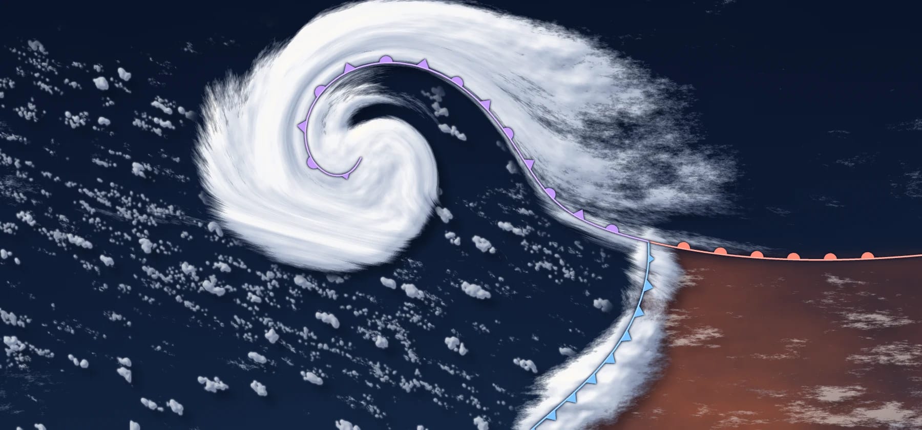
As a low deepens it winds up. The warm sector gets narrower, starting near the centre, until the warm air there has been squeezed off the ground altogether. The line that is left where the two fronts have joined is the occluded front, the purple one on the map.
- An open wave: warm air reaches right up to the low.
- The cold front closes in and the warm sector narrows.
- Warm air is squeezed off the ground near the low.
- The mature low, with the occlusion curling around its centre.
- Low
- Occluded front
- Warm front
- Cold front
- WARM SECTOR
- Dry slot
- COLD AIR
The classic explanation is that the faster cold front catches the warm front and zips it up, and the animation shows it in about that way. That is a simplification. Modern meteorology describes it more as the fronts wrapping around the low as it spins up. For reading a map the result is about the same: cloud and rain curl around the centre, often in bands rather than one even sheet, with the warm air pushed further and further away.
Cut through the purple line from the side and you can see what happened. The cold air behind has met the cold air ahead, and the warm air sits on top of them as a wedge, still making cloud as it is lifted. This is the cold type of occlusion, the classic drawing, and I use it because it is the easiest one to see. In the more common warm type, the air behind the front rides up over the air ahead instead of pushing under it.

- WARM AIR, lifted off the ground
- COLD AIR
- COLD AIR
- Cloud on the lifted wedge
- Rain
- Occluded front, cold air meets cold air
An occlusion shows that a low has wound up. Older books treated it as the end of the road, but it is the deepening that causes the occlusion. Many lows keep deepening for 12 to 24 hours after the occlusion forms, and some of the heaviest rain can come after that point. So a purple line on the map is no reason to relax. A mature low often moves slowly, and the cloud and rain curling around it can sit over the same airports for a long time.
The stationary front
Sometimes neither side wins. The boundary stops moving, the wind blows along it instead of across it, and you have a stationary front, drawn as alternating blue and red stretches. The weather along it is usually quieter than on a moving front, but it stays. Low cloud and rain can hang around the same area for a long time, and a small wave running along the line can grow into a new low.
The trough: not a front at all
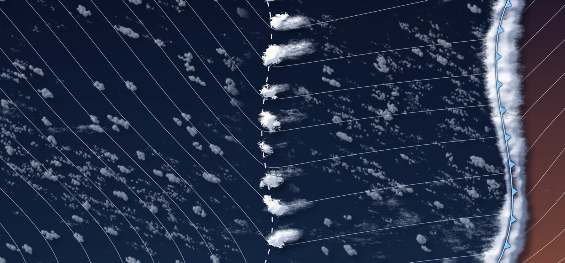
Then there is the line that is dashed in SkyNexus and on US charts, and solid on UK charts. That one is a different kind of thing. A trough has much the same air on both sides, so there is no air mass boundary. It is a long, narrow zone of lower pressure, and you spot it by the isobars, the lines of equal pressure, bending sharply where they cross it. The wind on both sides blows in towards it, the air converges and it has nowhere to go but up. Lift moist air and you get cloud, as ever.
- Trough
- Line of showers
- Isobars
- Cold front
- COLD AIR
Troughs matter because of where they turn up. Behind a cold front the sky has cleared and you have stopped worrying. But cold air flowing over a warmer sea is heated from below, so it is already unstable and full of showers. A trough in that air organises those showers and makes them bigger, and you can end up with a line of CBs, hail and sudden gusts well behind the front, in air you had written off as the good weather. Forecasters also talk about upper troughs, dips in the flow high up that may not show at the ground at all, and those are a different thing from the trough line on a surface map.
Reading it on satellite
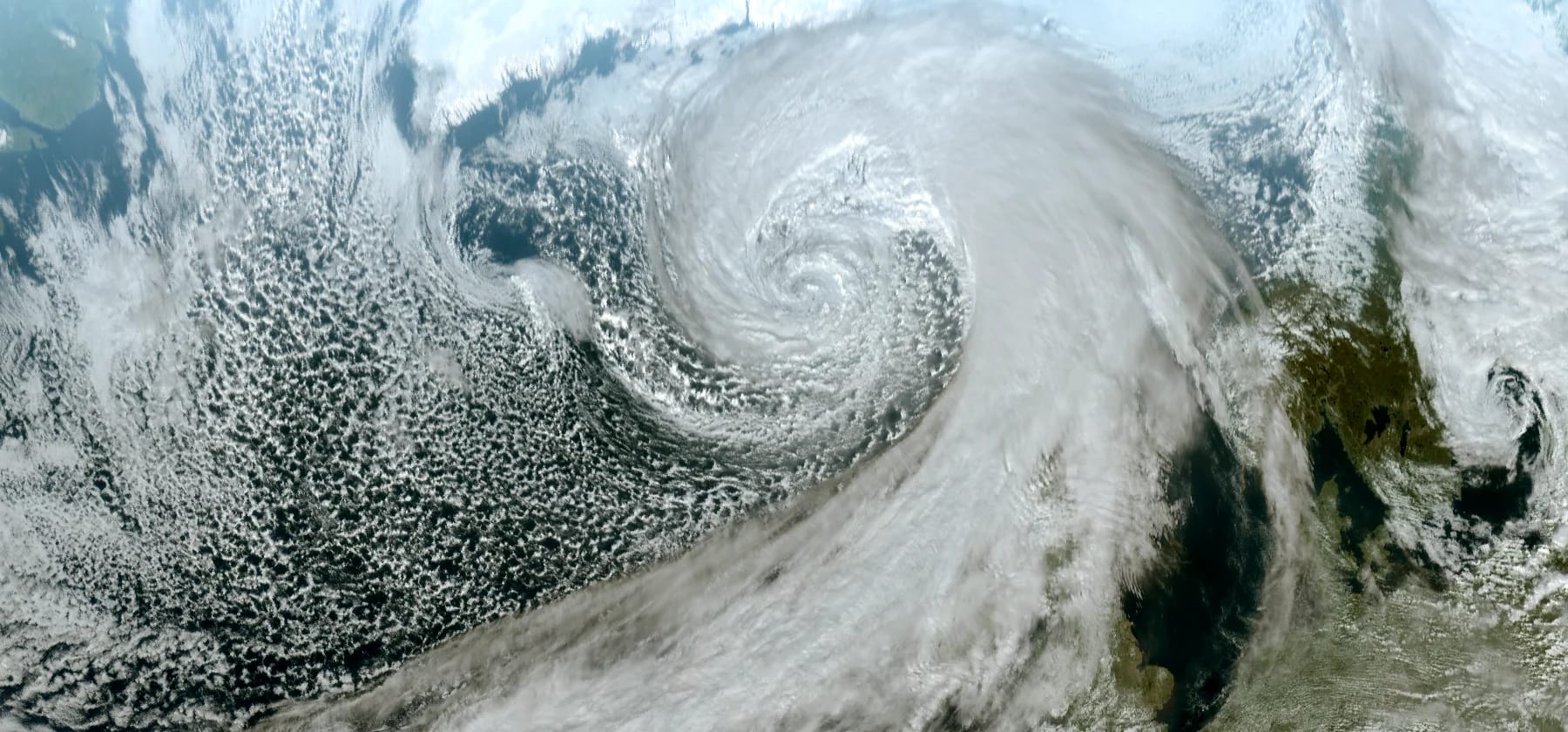
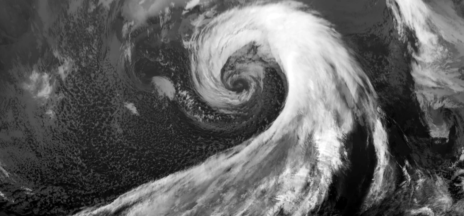
The drawings so far are tidy. This is the real thing: 14 October 2026 at 12:00 UTC, a 931 hPa low south of Iceland, seen by Meteosat. I checked the frame against an analysis chart for the same hour, so the fronts labelled here are where the analysis puts them.
- Comma cloud
- Warm front cloud shield
- Occlusion spiral
- Sharp edge of the band
- Cold front cloud band
- Shower cells in the cold air
I would start with the shape. It is the same comma as the drawing, with all the messy detail put back in. The tail is the cloud band along the cold front. Its edge on the cold-air side is sharp, because that is where dry air meets the cloud. The surface front is often near that edge, but it can lie inside the band. The broad shield ahead of it is the warm frontal cloud. Follow the band up into the head and the cloud winds into a spiral around the centre of the low. That spiral usually marks the occlusion area, though the surface line can sit away from it.
Behind the band sits a honeycomb of shower cells. That is the same cold, unstable air as in the trough picture, heated from below by the sea. There is no trough on this frame, but on another day one would show as cells lined up in a curve through a field like this, as in that picture.
- Comma cloud
- Warm front cloud shield
- Occlusion spiral
- Sharp edge of the band
- Cold front cloud band
- Shower cells, low and dim
The two images answer different questions. The visible one is sunlight bouncing off the cloud, so it needs daylight, and in return it shows texture. Infrared measures the heat coming off the cloud tops, so it works at night, and it shows cold high tops bright. Compare them and the height of the cloud jumps out. The outer comma and the frontal band are bright in both, because that cloud is thick and high. The inner spiral looks bright in the visible image, but in infrared it is mid grey with a dark core, because its tops are lower. The shower cells almost disappear in infrared, because their tops are low. My rule of thumb: a cell that is bright in both is a tall one, and worth a second look.
What it means for your flight
When I see a front on the route, the first thing I want to know is where I meet it. In the cruise a layer of frontal cloud is mostly a heading change and maybe a few bumps, as long as there are no CBs in it. Across a front the wind changes direction, sometimes by a lot in a short distance, and your drift changes with it. If you are flying a selected heading, the one that held your track a minute ago no longer does, which is easy to fix at altitude. The air can be rough in and around frontal cloud, and it is at its worst around the CBs on a cold front. The jet stream often runs roughly along the front on its cold side, and it brings clear air turbulence with it. The turbulence post goes through how to pick a smoother level.
The climb and descent ask for more care, because that is where the low cloud and the ice are, and where a wind change hurts most. Near the ground there is less room: a passing front can swing the crosswind or change the runway in use, so have a look at the other runway too if a front is due around your ETA. Expect low-level wind shear as well: on approach ahead of a warm front, and just after a cold front has gone through. On final that shows up as the speed jumping around while the autothrust hunts for it.
Then think about ice. The thick layer of nimbostratus at a warm front or an occlusion is a good place to collect it once you are above the freezing level, and on a long descent you can spend a while in it. I would have the engine anti-ice on before entering that layer. In winter, rain falling out of the warm air into freezing air below can turn to freezing rain. The icing post has the rest of that side.
The CBs you cannot see are the ones I would worry about most. A warm front or an occlusion is usually layer cloud, but unstable air can hide a CB inside the layer, where nothing shows out of the window. So do not trust a calm grey layer until you have checked the storm layers. The thunderstorm post shows how to find them before you go.
That leaves your arrival. A warm front near the destination means low cloud and rain that can stay for hours, so I would look hard at the alternate and the fuel. A cold front means a sharper change that is over sooner, and the question is when. In a TAF a warm front often reads as a slow BECMG to lower cloud. With a cold front the lasting change appears as FM or a short BECMG, with showers or thunderstorms in a TEMPO. Timing is the weak spot of any forecast, which is why reading the TAF at your ETA with a margin matters. If it puts a cold front right on my ETA, I would look at leaving a bit earlier or later, because in the sim that is free.
Read it in SkyNexus
All of this is on the enroute map. Switch on the Fronts layer and the legend lists Cold, Warm, Occluded, Stationary and Trough, which you can now read. Switch on the Satellite layer as well and you can look for the comma, the band and the spiral under the lines. I would pick Geo Colour for that, which is true colour by day and infrared by night, or IR if you want the cold high tops to stand out.
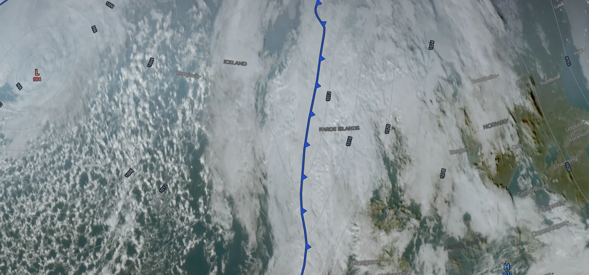
No forecaster draws these lines. The map is found automatically in the model, so it can differ from a chart drawn by a forecaster: it can miss a front or give it a different type. If a line and the satellite disagree about where the cloud is, believe the satellite. The fronts are there for every forecast step, so you can also move to your ETA and see what the front is doing by the time you get there. The weather map page explains every layer, and the briefing post shows where the map fits in a full weather briefing.
More in this series
- How to brief weather for a flight sim flight
- Thunderstorms in the sim
- Turbulence forecasts for sim pilots
- Icing for flight simmers
- The TAF at your ETA
- The SkyNexus weather map, with every layer explained.
Questions pilots ask
- What is the difference between a cold front and a warm front?
- At a cold front, cold air pushes under warm air along a steep slope, so you get a narrow band of tall cloud, heavy showers and a sharp wind shift. At a warm front, warm air slides up over cold air along a shallow slope, so you get a wide layer of cloud and hours of steady rain.
- How fast do fronts move?
- As a rough guide, warm fronts move at about 10 to 15 kt and cold fronts at about 20 to 35 kt. Fronts in a deep low can go faster, and a stationary front barely moves.
- What is an occlusion?
- It is what happens as a low winds up: the warm air near the centre is squeezed off the ground, and the warm and cold fronts join into one occluded front. It shows a low has wound up, not that it is finished: many keep deepening for 12 to 24 hours, and the cloud and rain around it can last a long time.
- What is a trough on a weather map?
- A long, narrow zone of lower pressure where the isobars bend sharply. Air converges there and rises, so it can set off a line of showers or CBs. It is not a front, because there is no real change of air mass across it.
- Which front is more dangerous for flying?
- They are dangerous in different ways. A cold front can bring thunderstorms, hail, strong gusts and wind shear just after it passes, but in a narrow band you get through quickly. A warm front looks calmer, but it brings long stretches of icing cloud, low ceilings and poor visibility, wind shear on approach, and sometimes embedded CBs you cannot see.
Try SkyNexus EFB
Free, browser-based, runs alongside MSFS 2024, X-Plane or P3D. Import your SimBrief OFP and get the full briefing in under a minute.
Get Started Free

